|
|
|
|
|
|
|
Sinuse
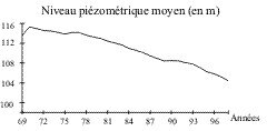
A tool to explore distributed interactions between a water table and its usersSarah Feuillette, Ird. The Sinuse model (Simulation of interactions between water table and water users) is designed to explore the ways of managing the demands made on an over-exploited water table: it should allow the definition of engines of system dynamics and of testing the effectiveness of different types of interventions, all while taking into account their social impact, key to their ultimate acceptance by the users. Sinuse has been developed for the case study of the Kairouan water table in Central Tunisia, over-exploited for the past twenty years, mainly by private wells (see following figure, showing evolution of the average water table level between years 1969 and 1999).
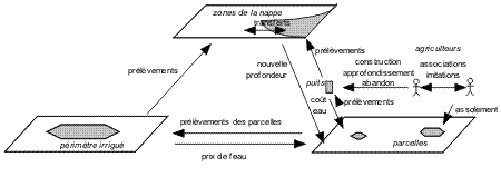
Individual strategies and interactions between agriculturists have been determined on the basis of surveys whose results have led us to the following hypothesis: all the agriculturists of the Kairouan plain have the same overall aim of acquiring or extending irrigation to alleviate their climate's aridity. The strategies used towards this aim depend on their plots, families, economics, access to resources, and neighbors' situations: a plot or group of neighboring plots should be large enough to make the well cost-effective. Since the water table is homogenous as to depth and structure, the access and extraction cost depend on the location over the water table and, finally, the presence of working wells in the neighborhood is an indicator of the accessibility of the water table and a social stimulant (whereas a disused well acts as a disincentive). This imitation process is reflected in the spatial dynamics of the appearance of wells. The zone under study extends to about 25,000 hectares. The Sinuse model represents a simplified and reduced plan of the system under study (approximately 10% of the system under study) while respecting, as far as possible, the proportions of the main parameters. It attempts to find a coherence between phenomena observed on the field and to be able to validate the model to some extent. The time step of interactions is the year, divided into two seasons. The Sinuse model consists of three types of entities (see the following figure): ·
The following figure shows the interactions represented by the Sinuse model..
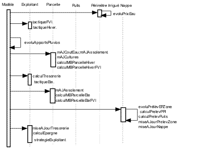
The users make basic exchanges and crop-planting and harvesting decisions. The irrigation of plots results in a sampling at the level of water points which transmit information to the water-table zone they belong to. These react by lowering themselves and the resulting piezometric gradient leads to transfers of volume between zones. Each Zone of the water table communicates its new depth to plots which may lead to deepening of wells (on the condition of non-indebtedness). The results of each agricultural season is calculated and, at year end, depending on his budget, his savings, and his situation, the agriculturist can consider construction of a well, if necessary in association with a neighbor, or by buying or selling a plot. Wells can also be constructed according to several types of procedures (on a small or large plot, in association with a neighbor or not, ) to which the users do not assign the same preference. In case of poverty, a user could be forced to sell a plot. The following figure shows the simplified running of a time step. Each class is shown by a dotted vertical line; the activation of objects of the class is shown by a rectangle on the life line. The objects communicate by exchanging messages represented by horizontal arrows, pointing from transmitter to the receiver.
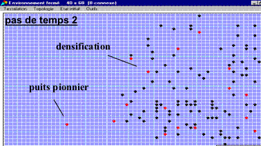
The display of the appearance of wells is made possible by the graphical interface of the model (see following figure).
The progression of wells (new wells in red) takes place more by densification of zones that are already occupied rather than by new ones in "pioneering" zones: in 7 successive time steps, the construction of wells in the virgin zone took place only in the second time step. Wells are historically concentrated in zones that are not deep (growing depth gradient from right to left). The rate of appearance of wells decreases with time because of spatial constraints and the lowering of the water table. For more information, contact the author.
|