|
|

|
CatchScape.
Conflicts over water in Northern Thailand.
An individual based viewpoint about catchment scale issues.
Nicolas Becu (ENGREF), Pascal Perez (CIRAD), Andrew Walker (ANU)
 In
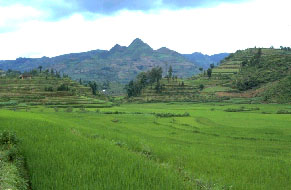
April 1998, an extraordinary event took place in Northern Thailand. Five
thousands lowland Thai farmers from the district of Chom Thong occupied
and blocked one of the district's main roads. They were demanding the
forced relocation of almost 20,000 hill-tribe villagers whom they accused
to cause widespread environmental damage: deforestation, forest fires
and streamflow drying. This event was the first sign of a global emerging
conflict between lowland and upland farmers of Northern Thailand about
natural resources management [Scoccimarro et al., 1999]. On one hand,
upland settlers are accused of reducing streamflow, through deforestation,
and, on the other hand, lowland farmers are increasing their demand over
water. Moreover, the conflict is emphasized by ethnical differences between
upland and lowland people. Regarding the complexity of the existing interactions,
solutions may only arise from local negotiation. But stakeholders need
descriptive, integrative and anticipating tools in order to share a common
view and to reach a sound consensus. In
April 1998, an extraordinary event took place in Northern Thailand. Five
thousands lowland Thai farmers from the district of Chom Thong occupied
and blocked one of the district's main roads. They were demanding the
forced relocation of almost 20,000 hill-tribe villagers whom they accused
to cause widespread environmental damage: deforestation, forest fires
and streamflow drying. This event was the first sign of a global emerging
conflict between lowland and upland farmers of Northern Thailand about
natural resources management [Scoccimarro et al., 1999]. On one hand,
upland settlers are accused of reducing streamflow, through deforestation,
and, on the other hand, lowland farmers are increasing their demand over
water. Moreover, the conflict is emphasized by ethnical differences between
upland and lowland people. Regarding the complexity of the existing interactions,
solutions may only arise from local negotiation. But stakeholders need
descriptive, integrative and anticipating tools in order to share a common
view and to reach a sound consensus.
 Towards
a fully integrative model Towards
a fully integrative model
In order to focus on social interactions and resources
management, we have first defined the farmers as cognitive agents (Farmer)
and then, the other elements that compose the farmer's environment: the
crops (Crop), the river (River), the irrigation canal (Canal) and the
village (Village) have been created as reactive entities. The Farmer has
to manage four main resources and their interactions: water, labor, cash
and land. The catchment has been schematically represented in order to
sketch the different levels of organization of the relevant spatial units.
First, the Land Units combine soil texture, soil depth and land slope.
The second spatial representation concerns Land Use: Paddy, Upland and
Forest. the Paddy zone is an irrigated area composed of a multitude of
bounded terraces on which farmers mainly crop rice during the wet season.
The Upland zone is constituted with rainfed plots spread all over the
hillsides and cropped either with rice, soybean or vegetables. Forest,
mainly used for gathering and religious ceremony, is described as a sempervirens
sole type cover.
Model description
 The
unit cell (Plot) that composes the modelling grid (44*45), corresponds
to a 2-rai farm plot (1 rai = 0.16 ha), which is the average size encountered
in the Mae Uam catchment. Farmers are characterized by their family size
and labor force. they can initially own upland and/or paddy plots according
to their status. A paddy Plot belongs to a Canal. There are six Canals
in the system, organized by pair and grouped into two irrigated schemes.
A cognitive agent, called Manager, manages the weir controlling a Canal.
The irrigated schemes belong to one zone each (Village) corresponding
to the upstream and downstream groups of actual villages. The biophysical
dynamics are simulated through a distributed water balance model and a
hydraulic model [Perez et al., 2001]. First, Farmers choose the most profitable
crop The
unit cell (Plot) that composes the modelling grid (44*45), corresponds
to a 2-rai farm plot (1 rai = 0.16 ha), which is the average size encountered
in the Mae Uam catchment. Farmers are characterized by their family size
and labor force. they can initially own upland and/or paddy plots according
to their status. A paddy Plot belongs to a Canal. There are six Canals
in the system, organized by pair and grouped into two irrigated schemes.
A cognitive agent, called Manager, manages the weir controlling a Canal.
The irrigated schemes belong to one zone each (Village) corresponding
to the upstream and downstream groups of actual villages. The biophysical
dynamics are simulated through a distributed water balance model and a
hydraulic model [Perez et al., 2001]. First, Farmers choose the most profitable
crop 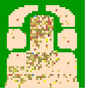 according
to their constraints in cash, labor force and water availability. Except
for rice during the wet season, the Crop choice is based on a simplified
Linear Programming model taking into account seasonal farming costs, water
and labor requirements.This initial Crop choice may be modified if the
growth duration doesn't reasonably fit within seasonal boundaries. The
planting date is delayed as long as Farmer's cash and labor force can't
match the land preparation and planting requirements. Rice cultivation
is mostly motivated by food security strategies. Thus, within the model,
Farmers are forced to plant rice at the beginning of the rainy season
as long as their yield expectation doesn't reach their family needs, cash
and labor resources permitting. At the beginning of the dry season, Farmers
have to decide whether they allocate part of their labor force to off-farm
activities or not. Finally, Farmers have to make decisions about land
dynamics. Three opportunities are offered to the cognitive agents. First,
Farmers can buy available Plots. Then, they can decide to install irrigation
on rainfed Plots (located in the uplands), in order to farm them during
the dry season. At last, Farmers can convert forest Plots into upland
Plots. Paired Canals enter into an irrigation rotation as soon as the
downstream canal faces water shortage. The upstream Manager is forced
to accept the rotation but may stop it if the River's streamflow comes
back to normal. Negotiations may involve Managers from different groups
of paired Canals and, eventually, from different Villages. In this case,
downstream Managers still send requests to the upstream ones but the later
are not forced to respond positively. according
to their constraints in cash, labor force and water availability. Except
for rice during the wet season, the Crop choice is based on a simplified
Linear Programming model taking into account seasonal farming costs, water
and labor requirements.This initial Crop choice may be modified if the
growth duration doesn't reasonably fit within seasonal boundaries. The
planting date is delayed as long as Farmer's cash and labor force can't
match the land preparation and planting requirements. Rice cultivation
is mostly motivated by food security strategies. Thus, within the model,
Farmers are forced to plant rice at the beginning of the rainy season
as long as their yield expectation doesn't reach their family needs, cash
and labor resources permitting. At the beginning of the dry season, Farmers
have to decide whether they allocate part of their labor force to off-farm
activities or not. Finally, Farmers have to make decisions about land
dynamics. Three opportunities are offered to the cognitive agents. First,
Farmers can buy available Plots. Then, they can decide to install irrigation
on rainfed Plots (located in the uplands), in order to farm them during
the dry season. At last, Farmers can convert forest Plots into upland
Plots. Paired Canals enter into an irrigation rotation as soon as the
downstream canal faces water shortage. The upstream Manager is forced
to accept the rotation but may stop it if the River's streamflow comes
back to normal. Negotiations may involve Managers from different groups
of paired Canals and, eventually, from different Villages. In this case,
downstream Managers still send requests to the upstream ones but the later
are not forced to respond positively.
Preliminary results
Each scenario has been run over a 10-years period, corresponding
to the existing climate data set . As several random functions are included
in the algorithm, the scenarios have been repeated 20 times in order to
estimate the outputs variability. The user can visualize the spatial and
social dynamics during simulations according to different viewpoints (Cropping
pattern, soil water balance, irrigation canal depletion, individual cash,
conditions of negotiation
). At the end of the simulation, a set of indicators
can be edited through evolution charts or export files [Bousquet et al.,
1999]. In the basic scenario, social inequity has dramatically increased
in the catchment at the end of the 10-year period. Approximately 10% of
the Farmers enjoy a positive cash position (Rich) and gradually increase
their wealth. Some of them are rich enough to invest into upland irrigation
(15 cases). Meanwhile, 40% of the Farmers (Poor) enter a permanent and
worsening deficit position. The remaining 50% hardly maintain their economic
buoyancy. Even if Farmers initially entitled with only 2 upland Plots
partly feed the Poor category, the irrigated Plot location along the Canal
largely contributes to its owner economic achievements. For example, during
the dry season, the upstream Canal (C1) can secure enough water to irrigated
approximately 65% of its Plots. But the downstream Canal (C6) can hardly
support 20% of the connected Plots. In this case, as Farmers were endowed
with the ability to learn from previous failures, gradually, the number
of attempts to crop during the dry season decreases.
References
Bousquet, F., O. Barreteau, C. Le Page, C. Mullon and J.
Weber, An environmental modelling approach. The use of multi-agent simulations,
In Advances in environmental and ecological modelling, (Eds, Blasco, F.
and A. Weill), Elsevier, pp. 113-122, 1999.
Perez, P., N. Ardlie, P. Kuneepong, C. Dietrich, W.S. Merritt,
CATCHCROP: Modeling crop yield and water demand for Integrated Catchment
Assessment in Northern Thailand, Submitted to Environmental Modelling
and Software, 2001. Scoccimarro, M., A.
Walker, C. Dietrich, Schreider, A.J. Jakeman, H. Ross, A
Framework fir Integrated Catchment Assessment in Northern Thailand, Environmental
Modelling & Software 14, 567-577, 1999.
For more information, contact the authors. N.
Becu, P. Perez
|
|
